


Have you ever been to Pacheco State Park? We go there quite often because it is pretty close to our 'home base'. It has great trees and skies for photos and nice trails to walk on with family. This I borrowed from the California State Park discription, but it tells all about the park and the history. Please take a gander when you have a chance.
Pacheco State Park is the last remaining portion of the Mexican land grant, El Rancho San Luis Gonzaga. Francisco Pacheco and his son Juan were granted the property and built the first house in Merced County on this land in 1843. The land remained in the Pacheco family through five generations until Paula Fatjo, the great-great granddaughter of Francisco Pacheco, donated the land in 1992 to be a park for future generations who share her love of animals, horse back riding, history, and unspoiled land. This land has been a horse and a cattle ranch since 1843 and has breath taking views of the Central Valley to the east and the Santa Clara Valley to the west.
The park has beautiful displays of spring wildflowers, scenic vistas, and outstanding trails for horse-back riding, hiking, and mountain biking. The 28 miles of trails offer several loop options to give visitors the choice of a hike or ride of from one to twenty miles or more. During the spring the park's grassy slopes abound with blossoming wildflowers. The park is home to tule elk, deer, bobcat, coyote, fox, several hawks, golden eagles and many other smaller animals. Cattle continue to graze on the ranch in the winter and spring months.
Among the historic features of the park are an old line shack used by Henry Miller's cattle company in the 1800s, part of the old Butterfield Stage line route, and the remains of the original Pacheco adobe. There is also a wind turbine farm which generates enough clean electrical power for 3,500 homes.
Although the total park area is 6,890 acres only the western 2,600 acres are open for public use at this time.
Location/Directions: Pacheco State Park is located 24 miles west of Los Banos or 20 miles east of Gilroy off Highway 152 on Dinosaur Point Road.
Address:38787 Dinosaur Point Road
Hollister, CA 95023
Telephone: (209) 826 6283 Fax: (209) 827 3704
Operation Hours: All year. Day use hours are 8:00 a.m. until sunset.
Seasons/Climate/Recommended Clothing: The area is semiarid, with daytime temperatures ranging from 80 to 100 degrees in the summer and 45 to 65 degrees in the winter. Evening are quite cool all year due to coastal marine air moving eastward across the Pacheco Pass. Remember to bring a hat, sunscreen, and a lot of drinking water especially in the summer months.
Camping: There are no facilities for camping except for special events. There is no potable water for human consumption at this time but there is water in the park's several lakes for horses. Camping is available at nearby San Luis State Recreation Area.
Recommendation: During the mild spring and fall months, visitors are encouraged to roam the hills that have been traversed by Central Valley Yokut Indians, Spanish missionaries and soldiers, Mexican vaqueros, gold seekers and bandits.
Special Events/programs: Springtime guided walks and rides highlight park history and wildflower displays. Call the park for dates and times.
Fees: $5 day use fee per vehicle
NOTE: No Dogs allowed on the trails
favorite snap of the day
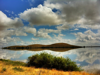
This is one of our favorite places to go walking, especially after a storm. The stormy skies reflecting in the water are always wonderful to see and make for beautiful snapshots. This is a walk we take on a paved trail in San Luis Creek, San Luis Reservoir.
MAP
MAP

Yummy travel smells
Since we travel almost all of the time, we have gotten pretty good at finding good smells to bring into the hotels with us. I love these new travel sized scents, they are so easy to pack along in the suitcase or in the car and really make you feel like you're at home even when you're not. Check them out, there are tons of different choices.
Travel smells~bring your own!
Travel smells~bring your own!
Subscribe to:
Posts (Atom)
